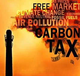
Politics

Bakken Formation Myths

Bakken Formation Urban Legends

1. Oil shales are mined not drilled!  —WRONG!

Unfortunately, I have seen this stated about the Bakken more than once. Why? Some people have just enough knowledge to be dangerous.   There are oil shales that can be mined. However, the Bakken formation does not fit this category.  The Bakken is thousands of feet underground, and contains mature “sweet crude”. In contrast, shallow mineable oil shales contain kerogen which does not easily flow, and may appear waxy or have similar properties grease or tar.  There is a window of heat and pressure that is favorable for oil to mature (Oil window ca. 60°-120°C, gas window ca.120°-150°C). Mineable oil shales typically missed at least one part of the oil formation process.

In some cases it is possible that bacteria degraded the oil in shallow oil shales, but biological degradation is more common in tar sands, and is not typically used as an explanation for oil shales.

If you want to know more about mineable oil shales.

Read the two web pages first.

http://www.npc.org/Study_Topic_Papers/27-TTG-Oil-Shales.pdf

http://ostseis.anl.gov/guide/oilshale/

Then watch this video, and keep in mind that oil shale mining is a water intensive process, and the formation happens to be in a very arid region of the United States.

2. The cost of extracting oil from shale is prohibitive.

Again, this myth often falls back to people not understanding that the Bakken is a deep formation and is not mineable.

There are no outcrops of the Bakken, and it is only accessible through drilled oil wells.  Typically, Bakken wells have at least one horizontal leg, and the Middle Member of the Bakken is the target unit because fluid can flow through the middle member much better than the upper and lower members (orders of magnitude). Drilling Bakken wells is expensive, and it often costs more than 5 million dollars per well. However,  the current drilling boom in North Dakota should speak for itself.  The majority of the drilling in North Dakota is focused on the Bakken, and it is expected to continue into the foreseeable future.

As of today there are 96 Rigs drilling in North Dakota.  Last year at this time there were around 70.  In 2007 there were over 120.  The drop was a result of the stock market and energy crash.

In order to make the Bakken wells economically viable I have seen figures that oil prices needs to be anywhere between $30 and $70 a barrel to be profitable.

Economic data is hard to come by if you have read anything good let me know.

3.  There are 400 Billion barrels of oil recoverable in the Bakken.

Sorry…

Supposedly Richard Pollastro, Bakken Formation task leader at the USGS, said the myth stemmed from a 1999 draft report. Which may or may not be true.

The  misconception was common in 2008, but I still see it posted from time to time. A few weeks before the USGS released their updated estimates for recoverable oil in the Bakken. Several media outlets and hundreds of bloggers saw very large OOIP numbers like  “400 billion bbl OOIP” in documentation that was written for people with a background in geology.  Unfortunately, they did not know that “OOIP” is an abbreviation for Original Oil in Place which means that the geological formation had the potential to generate 400 billions barrels of crude oil. Just because Bakken had the potential to generate the oil  does not mean that we can retrieve it. The oil may have even migrated out of the formation which can be difficult to track. Currently the Bakken is expected to give up 2 to 5 percent of the original oil in place (OOIP).  Regardless of the OOIP the USGS’s estimate for actual recoverable oil is around 3.65 billion barrels with current technology.

From what I read some industry leaders think that number is very low. Future recover rates will likely be improved by advances in technology, but it is not something to rely on.  Even in the best case the recoverable oil from the Bakken will probably be less than 10%.  Why? Porosity an permeability are extremely low and even though the oil is there it is unable to flow to the well.  It is very difficult to fix something that is more than 8000 feet below ground.

4.  Original Oil in Place “OOIP” numbers are all over the place geologists are full of crap!

True!    In reality OOIP numbers have ranged from 900 to 200 billion bbl depending on which calculation method you choose to go with. The number is calculated using organic content, volume, and thermal maturity.

There is a lot of variation because several different people have calculated the amount of oil in the Bakken. The following are some reasons for the deviation.

-  Some people like big numbers :-)

-  Knowledge of organic content has been better mapped.

- Thermal maturity may have been ignored in some calculations

- The volume may have been poorly constrained. (Geographic area)

-  What we thought we knew about thermal maturity has recently been turned on its head because the thermal gradient may have been improperly calculated for the large portions of the North American continent.  (How fast it gets hot as you go down)  Basically thermal gradient was calculated using water wells in the northern portion of the United States.  Unfortunately, water wells can be affected by surface climate, and the last glaciation put a strong signal into the upper portion of the earth’s crust which skewed the results in the thermal gradient calculation.   What this all means is that a much larger area of the Williston Basin is likely thermally mature than previously thought.

http://www.wbpc.ca/assets/File/Bios%20and%20Presentations/8_Gosnold.pdf

http://www.bsc.nodak.edu/gpee/presentations09/WilliamGosnold.pdf

Expect to see some updates or related posts on this subject in the future.

If you would like to be extra nerdy you can read this.  Everything through about page 50 is background information on the Bakken.  (Not focused on Petroleum)
Huber, T. P. 1986. Conodont biostratigraphy of the Bakken Formation and
lower Lodgepole Formations (Devonian and Mississippian), Williston
Basin, North Dakota. Unpublished Masters thesis, University of North
Dakota, Grand Forks, N.D.

This is probably the only OCRed copy in existence.  Any grammatical errors are probably a result of the OCR process. Let me know if you find any major mistakes.

1 comment - What do you think?  Posted by Ben - March 2, 2010 at 12:30 am

Categories: Energy, Geology, Mining, Politics, Science   Tags:

Snowmobiler will Drown in Grand Forks

Normally I’m the type of person who thinks that people should be responsible for their own actions.  However, there are cases in which the community should take preventive action to avoid stupid accidents and deaths.  In this case, I’m talking about the Riverside Dam in Grand Forks, North Dakota.  There is enough current in that location that the river never freezes, and the river is basically used as a highway for snowmobilers.

Today while hiking near the river I noticed a set of old snowmobile tracks that went into the open water, and I’m not totally sure if the snowmobiler made it across or not.  Last year two snowmobilers went in at the same location.  So far there have not been any fatalities that I know of, but it is only a matter of time until some unlucky snowmobiler losses track of where they are on the river and get sucked under the ice.  It is not very deep, but it would be easy to be thrown from the sled swept under the ice by the strong current.

It is purely negligent to not have warnings up all over the place.  Open water sings with blockades should be posted up and down river from the dam.  There will surely be an accidental death in the future that could have been  avoided if something is not done.

I was talking to a snowmobiler on the tail, and he mentioned that the cities could not post signs because they could be held liable for accidents.   It is my opinion that they should be held liable for not having the location marked.

Unfortunately, I do not know much about law, but it seems that this sort of thing should almost be covered under something like the Good Samaritan Law.  It is just common sense that the area should be well marked, and posting signage should not make anyone liable.  I might take the time to call the city and the police department to see if anything can be done.

Decide for yourself. Does this seem like a good idea?

I’m sure others have noticed the same problem. Make some calls if you would like to help.

Why I care…

Unfortunately, I had a similar experience  in 2005 when I noticed a section of road construction on highway 19 near Minnewaukan that was poorly, but legally marked.  I was a Park Ranger  and worked the night shift.  I hit the section about 1 a.m. on my way home.  Lucky I wasn’t going very fast.  I remember telling my mom that someone would die because of the way that road was marked and sure enough within the week someone ramped off the road and drown at the intersection of Highway 281 and 19. Unfortunately this was a stupid death that never should have happened.

I didn’t talk to the right people. I’ll try not to make the same mistakes twice.

Be the first to comment - What do you think?  Posted by Ben - February 21, 2010 at 11:54 pm

Categories: Photography, Politics   Tags:

Snow Storms and Global Warming->(Climate Change)

Normally I try to stay out of the Global Warming debate because I really don’t see it as a debate, but lately Fox New has really irritated me.  Snow storms in no way represent the world as a whole.  Are their newscasters really as stupid as the sound or is all just a ratings game to them?  Sadly the people who watch Fox News often believe what they hear and the newscaster’s stupidity is passed along to the viewers.

People really should realize that humans do in fact have the power to screw up the planet in a multitude of ways, but for some reason there is still debate on the topic.   CO2 and particulate in the atmosphere have an effect on the global climate.  It is possible that climate change is partially/dominantly natural, but humans are defiantly having an affect on the rate of change.

Normally both MSNBC and Fox news are total crap, but MSNBC is right about this one.

Be the first to comment - What do you think?  Posted by Ben - February 15, 2010 at 1:28 am

Categories: Meteorology, Politics, Science   Tags:

The Devils Lake Outlet

Most people are not familiar with Devils Lake, North Dakota so I will give you some background information. Devils Lake is the largest non-manmade lake in North Dakota. The lake is endorheic (a closed basin). In the late 1800s a ferry ran from Minnewaukan to Devils Lake. A dry climate in the early 1900s caused the water level to drop, and by the 1940s the lake was nearly dry. Since humans have an incredibly short memory roads, buildings, and cities where built on the lake bottom. In 1993 a region wide wet cycle began and has continued on ever since. Even though there have been some dry years the average precipitation has been significantly higher than the long term average. Many of the structures that were built on the lake bottom were lost to the rising water. The exceptions, of course, are those that demanded human intervention which could have been avoided if history had not been ignored.

Devils Lake Hydrograph

Devils Lake Hydrograph

Avoidable major projects.
Dike
Built a dike around the City of Devils Lake which permanently has the pressure of the lake pushing on it and could/will certainly cause it to fail. However, a failure would likely not cause loss of life because the water level should rise slow enough that people will be able to move out of the way, but water would still destroy much of the city.
Roads
Raised Highway 19 at least 3 times
Raised Highway 281 2 times and later forced it to be moved and re-routed ~ 1-3 miles West of original location
Raised Highway 20 and 57 at least 3 times
Raised the Grahams Island Road at least 3 times.
Cities relocated
Forced the City of Churches Ferry to be relocated

This list should give you a pretty good idea of the situation in the region.

Each of these projects cost the state and federal tax payers millions of dollars, and estimates place total cost on levee system, roads, etc at $ 700-$800 million which does not include agricultural production loss. The number is especially staggering when one considers that the population directly affected by the lake is probably less than 15,000 which is about $50,000 per-person.

The remainder of this post will focus the existing and potential outlet systems for Devils Lake. The state run outlet system is on the West end of Devils Lake, and was constructed in 2003. The system uses a series of ditches and two large pumps to move the water from Devils Lake to the Sheyanne River which is more than 100ft up hill over the divide between the basins. The outlet has basically done nothing for the lake level, and it never will because the volume of water the the pumps are able to move is simply insignificant when considering the size of Devils Lake.  The system will be expanded in 2010, but even with doubled capacity will have little impact on like level.

Devils Lake Outlet Pump

Devils Lake Outlet Pump

This is one of the two large pumps for the state run outlet.

GoogleEarth File Containing Outlet Locations

The large elevation difference disappears from west to east. At the east end of the lake (Historically called Stump Lake) there is little elevation difference that divides Devils Lake from the Sheyanne River. There are two obvious outlet channels that the lake has utilized in the past. The current level of the lake is ~1450, but could easily reach 1453 in the spring of 2010. If/When the water reaches an elevation of ~ 1458 above sea level. The Tolna Coulee outlet will become active. If the water flow is uncontrolled the current would start to remove the sediment that has been deposited in the channel since the last time the outlet was active, and it could easily cause severe flooding problems down stream. Drill cores have been taken in the Tolna Coulee channel, and tree stumps have been found several feet bellow the surface which seems to indicate that the outlet should already be active, and is only inactive because it filled with sediment since the late time the outlet was active. A simple sweep with a ground penetrating radar should be able to confirm if the actual depth of the channel is great enough that the water should be flowing.

It seems likely that the lake will achieve the required elevation to initiate the outlet naturally, but there is no way that the lake will be allowed to drain uncontrollably. If left unchecked the flow could quickly remove the sediment, and flow could increase to enormous proportions. The cities down stream (Valley  City, Fargo, and Grand Forks) simply would not allow Devils Lake to contribute to already intense spring flooding problems. The logical thing to do is to preemptively build a control system on the Tolna Coulee, and remove the sediment from the old channel so that the lake is allowed to be discharge slowly. The other option is to allow the lake to naturally overflow and face intense local opposition to controlling the outflow. If a Tolna Coulee project is started now that scenario could be avoided and control mechanisms would be better accepted by locals who already want an outlet.  If no outlet project is stated locals may strongly oppose flow restrictions that will need to be put in place a few years down the road.

Articles you should read if you want to know more
https://www.dmr.nd.gov/ndgs/Devils_Lake/devils.htm

Devils Lake 1991

Devils Lake 1991

Devils Lake 1997

Devils Lake 1997

Devils Lake 2004

Devils Lake 2004

Devils Lake 2009

Devils Lake 2009

*This post will be edited as I did not address water quality issues, but I may do so in the future
Reference http://www.ci.devils-lake.nd.us/documents/minutes/2009/09-24-09.pdf

Be the first to comment - What do you think?  Posted by Ben - December 23, 2009 at 2:16 am

Categories: GIS, Geology, Politics, Science   Tags: , ,

Please visit WP-Admin > Options > Snap Shots and enter the Snap Shots key. How to find your key